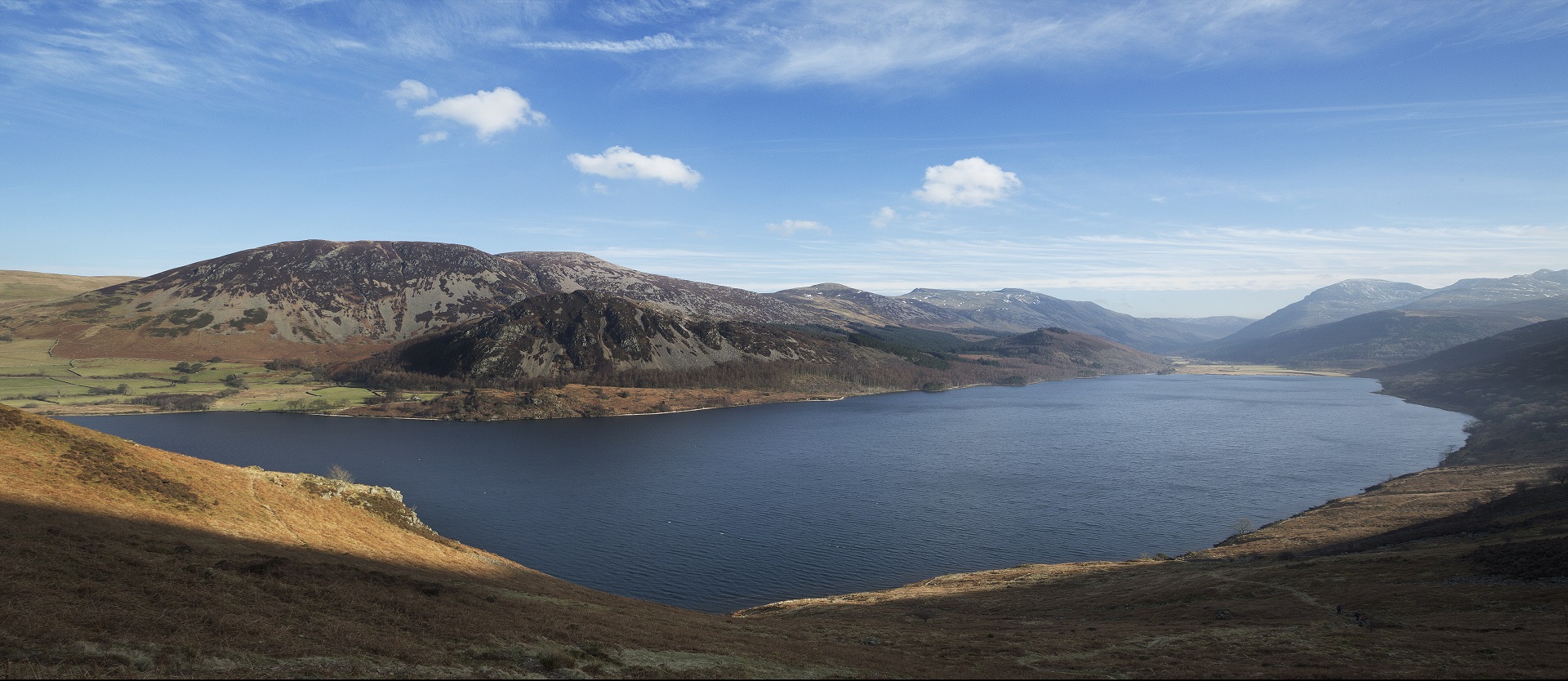
Our long-term plans for Ennerdale Water
Ennerdale, Crummock Water, Chapelhouse Reservoir and Overwater are no longer used as sources of water supply. We're developing plans to return all these water bodies sensitively back to nature. Our plans for Ennerdale are still in the early stages and this information will be updated as our plans progress.
We've been working with key stakeholders including the Environment Agency, Natural England, Lake District National Park Authority, National Trust and the Forestry Commission to develop long-term plans that would maintain access for visitors, while sensitively returning Ennerdale Water back to a more natural state.
There's still a long way to go before any work begins, we're still in the early stages for Ennerdale and are further along with our plans for Crummock Water, Chapelhouse Reservoir and Overwater. We've held two drop-in information sessions to share our initial plans with the community and answer queries about our proposed work at Ennerdale (September 2023 and September 2024). If you've attended any of these sessions, thank you for taking the time to come and see us.
You can view the information displayed at our September 2024 session here.
Our next steps
Over our next funding cycle (AMP8), which runs from 1st April 2025 to 31st March 2030 the Ennerdale scheme will move into outline design and will be developed to a similar level of detail as our project for Crummock Water. We have appointed AtkinsRealis to undertake this work and, as we move through this phase of the project, we'll arrange further community drop-in sessions later in 2026 when we have further information available.
For more than 120 years, water for 80,000 homes and businesses in and around the towns of Egremont, Cockermouth and Whitehaven has come from local sources. But the waterbodies are also home to many rare and protected species. The risk to wildlife, along with the growth of the population means we had to find sources other than Ennerdale Water, Crummock Water, Overwater and Chapelhouse Reservoir.
We worked with environmental stakeholders including the Environment Agency and Natural England and stopped using these water bodies as a water source at the end of March 2023.
Our West Cumbria abstraction licences are now permanently withdrawn as the new water network is operational and uses Thirlmere Reservoir as the water source.
Bringing water to the 80,000 homes and businesses via the new 62-mile long pipeline from a more strategic water source, Thirlmere reservoir, means we can better meet the demands now and for future population growth, while also protecting the very precious local environments by not taking water from these smaller sources.
Revocation of the abstraction licence at Ennerdale was a requirement from the Environment Agency under the habitats directive. We built the IROPI (Imperative reasons of overriding public interest) case to allow us to continue abstraction at Ennerdale Water until an alternative solution was found.
The feasibility study looking at the removal of the infrastructure was a requirement under the Water Industry National Environment Programme (WINEP). This has been completed by our specialist consultant partner, Jacobs, with the Project Steering Group last funding cycle.
We have undertaken significant investment over the past 15 years and continue to do so, to enable more water to be moved around our network regions more readily.
An example of one of these projects is the West East Link Main that connects Liverpool to Manchester, enabling Manchester to be supplied by alternative sources and is therefore less dependent on Thirlmere.
Thirlmere is a large strategic water source and part of our integrated regional water supply system. We will be using more of the water from Thirlmere to supply homes and businesses in Cumbria and use capacity at other sources in the south of our region to make up the difference.
Our Water Resources Management Plan (WRMP) sets out how much water we think our customers need, how much we have available and how we will meet that supply and demand.
Experts assess and model what will affect the demand for water in the future and take into account factors like population growth and the impact of climate change. Based on those assessments, which have also been subject to scrutiny by a DEFRA appointed planning inspector, Thirlmere's the right solution to meet the needs of the population now, and in the future.
You can view our updated draft Water Resources Management Plan which defines our strategy to meet demand from 2025 to 2085.
Revocation of the abstraction licence at Ennerdale was a requirement from the Environment Agency under the habitat directive and under the Water Industry National Environment Programme (WINEP), there is a need for the removal of the infrastructure.
The weir at Ennerdale Water is not designed or operated as a flood risk management provision as the structure is designed to retain water for drinking water abstraction, above and beyond, the natural storage provision of the waterbody.
If the infrastructure was abandoned, someone would have to take ownership and responsibility under the Reservoir Safety Act to modify the infrastructure into a flood management system, combined with the liability of proactively managing flood waters which isn't cost effective. Re-naturalising this reservoir is the most viable solution, enhancing the environment and cost.
With the completion of the new Thirlmere pipeline and water network the existing water treatment works at Ennerdale will no longer be operational and will be taken out of service. As a result, there would be no way for the water from this reservoir to be transferred using the existing pipework to the new treatment works at Williamsgate and would require significant new lengths of pipework to be installed.
Also, the abstraction licences from the Environment Agency for this site have been revoked and therefore we are not legally allowed to take water from this site. It would also be very unlikely that we would get permission to do so in the future.
We must demonstrate to the Environment Agency (EA) and Cumberland Council through the planning and consenting process that our assessment of flood risk is in accordance with National Planning Policy and that flood risk, to and from, the proposed project can be managed effectively and without increasing risk to others. This will look at the whole catchment as far downstream as where it joins the River Calder and goes out to sea adjacent to Sellafield.
We will continue to engage with specialists and the Environment Agency to carry out extensive hydraulic modelling studies to assess how the proposed work at this site may alter flows. The initial modelling results suggest a lowering risk and flood peaks - we will continue to work with specialists to ensure that there would be no increase in flood risk.
If we are not able to demonstrate that flood risk is not increased (including taking climate change into account), the project would be unable to obtain planning permission and therefore not progress into construction.
We are looking to undertake further work to assess the lake levels for various flows and this will be presented at the community drop-in session planned for later in 2026.
During any construction activity we carry out, safety is always of utmost importance. Therefore, access to several areas around Ennerdale Water would be restricted, along with closures of some access routes during the work.
We'll look to minimise impacts and provide temporary alternative routes to areas not impacted by our work where possible and when it becomes safe, return the existing routes to users as quickly as possible. We would also make sure that long-term pedestrian access is not restricted and the impact of our work is kept to a minimum.
We would work closely with the Lake District National Park Public Rights of Way Officers as well as other interest groups.
Although there are no plans to change the long-term recreational use of Ennerdale Water for permitted leisure activities (as set out on the LDNPA website), we would look to undertake assessments to understand the shoreline gradients and whether the lowered water level will impact access to the water. Any temporary localised diversions of Public Rights of Way/access routes will be minimised as far as possible.
We understand that Ennerdale is a valued space and an important landscape for visitors and the surrounding communities. The lake, river and much of the surrounding catchment are designated for their unique and important habitat and species. Ennerdale Water was also recently declared a National Nature Reserve.
The purpose of the project scheme is to deliver long-term benefits, which would include:
- The restoration of natural salmon and freshwater mussel habitat
- Removing barriers to fish and eel movement
- Restoring natural flows and sediment transportation
- Improving river habitat quality
We're working with a range of partners, stakeholders and engaging with specialist ecological contractors to carry out surveys and assessments, the majority of which will be undertaken during phase two of the project.
We're currently collating information on the construction impact at this site and, as our plans develop, this would be made available and updates provided at community drop-in sessions and on this dedicated webpage.
Bleach Green car park
We currently have no plans to close or introduce car parking charges at any of the United Utilities car parks in the Ennerdale valley.
Ennerdale Water Treatment Works buildings
As the pipeline from Thirlmere is now in operation and supplying customers, the land and buildings at Ennerdale Water Treatment Works are in the process of being decommissioned. The buildings and hardstanding areas are likely to be used to support the removal of the abstraction infrastructure, which is planned to take place between 2030 and 2035.
Following completion of this scheme, alternative uses for the buildings may then be investigated. There would be significant upfront work required before it would be feasible for the building responsibility to be passed onto a third party. Any proposed alternative uses would be presented to the Parish Council and subject to local engagement prior to options being taken forward.
Any alternative uses would require planning permission from the Lake District National Park Authority and there would also be the opportunity to comment on this through the planning process.
Low Moor End farm
We purchased Low Moor End farm in 2014 as part of the Compensatory Measure's Agreement (CMA) with Natural England, the Environment Agency and ourselves. The purchase and subsequent management are intended to minimise risk to the River Ehen. The CMA requires that land at Low Moor End is permanently removed from agricultural use.
In 2022, the land was incorporated into the Wild Ennerdale National Nature Reserve and will be managed under those principles. There is no intention to bring the buildings in Low Moor End back into residential use at the moment.
The CMA requires that Natural England and the Environment Agency are consulted on proposals for any future use of the buildings, which would also require planning permission from the Lake District National Park Authority. In advance of any planning application being made, we would discuss the proposals with the Parish Council and local residents.
Wild Ennerdale is a partnership between people and organisations led by the National Trust, Forestry England, United Utilities as the primary landowner in the Ennerdale valley and Natural England, the Government's advisor on the environment.
We're committed to working with Wild Ennerdale and the various partner organisations and this extends throughout the lifecycle of the project. Wild Ennerdale, together with other organisations including the Environment Agency will sit on the Project Steering Group for the scheme.
The Wild Ennerdale Stewardship Plan is due for renewal in 2028 and we will ensure that the proposals for this project form part of this and are reflected in the updated plan.
The scheme has now moved into the outline design phase, which will ultimately lead to submission of a planning application and Environmental Statement to the Lake District National Park Authority (LDNPA).
We have appointed Atkins Realis to undertake this work and, as we move through this phase of the project, we'll arrange further community drop-in sessions later in 2026 when we have further information available.
The exact scope of the Environmental Statement will be confirmed with the LDNPA via the submission of a Scoping Opinion. As a public document, there will be opportunities to comment on the content via the Lake District National Park Authority.
Following feedback at the September 2024 drop-in session, we wanted to clarify that the following activities, surveys and assessments would be carried out in the next phase of the project and information would be available at our next planned community drop-in session.
- Visualisations of key viewpoints from various locations (weir, infrastructure which would be removed and surrounding fells). This would help to illustrate the appearance of the proposed scheme on the landscape.
- Development of landscape proposals such as tree planting and, where appropriate, land management.
- Ecology surveys which would include assessing the impacts on fish (e.g. minnows, arctic charr and salmon) along with freshwater mussels and appropriate land-based surveys.
- Working with the LDNPA Rangers and Public Rights of Way Officers to ensure that the proposed permanent scheme and associated construction activities are suitable from an access perspective.
- Heritage assessments which would include the review of old photographs and, where available, mapping of the lake.
- Surveys to determine the type of shoreline around the lake margin and the creation of plans to provide visualisations.
- Assessments of any potential temperature variations impacting the reduced footprint of Ennerdale Water.
- Low flow assessments downstream in the River Ehen to determine the range of flows in extended periods of dry weather/drought.
We hope you have found this information about our long-term plans helpful. We’ve previously held a community drop-in session as part of the feasibility assessment and really welcomed your feedback. There will be a number of further community drop-in sessions as the scheme develops and we will provide information on the timings of these sessions. In the meantime, if you have any queries, please complete our feedback form.